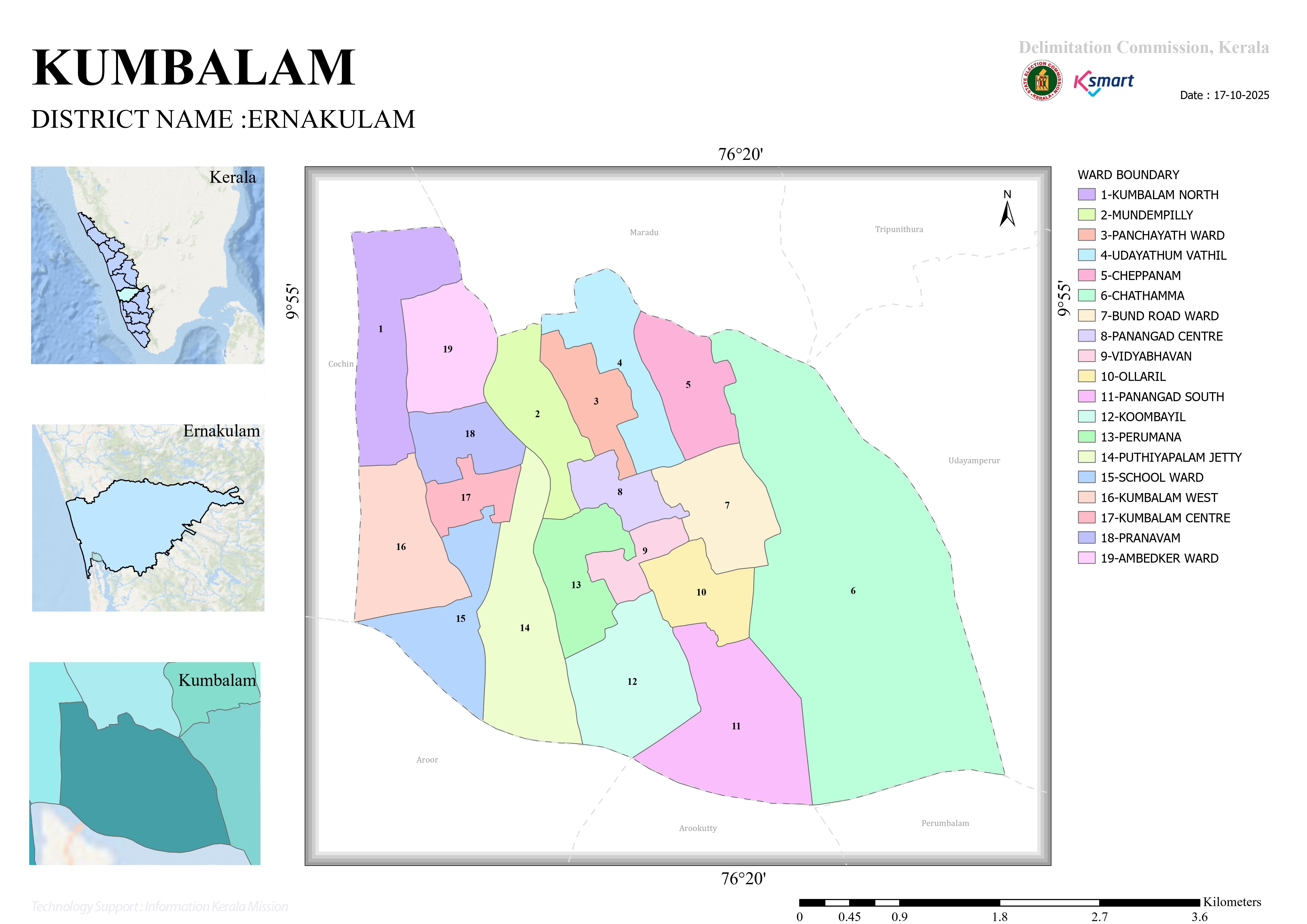
MAP
🗺️ Kumbalam Grama Panchayat Ward Map – Analysis Report
1. General Information
- Area: Kumbalam Grama Panchayat, Ernakulam District, Kerala.
- Prepared by: Delimitation Commission, Kerala (through the K-SMART system).
- Map Date: 17-10-2025.
- Geographical Coordinates: The map indicates Latitude 9°55' N and Longitude 76°20' E.
2. Geographical Features and Boundaries
The map highlights the following major geographical characteristics:
Island-like Structure
Kumbalam Panchayat is a region surrounded by water bodies (backwaters), giving it an island-like geographical character.
Neighboring Areas
- North: Maradu Municipality
- East: Udayamperoor
- West: Kochi
- South: Arookutty and Perumbalam
3. Ward Layout and Observations
The Panchayat is divided into a total of 19 wards. Based on the colors and numbering shown on the map, the following observations can be made:
🌐 Eastern Region
Ward 6 (Chathamma)
Shown in green on the map, this is geographically the largest ward. It is located at the easternmost end of the Panchayat, adjacent to the backwaters, and remains relatively isolated from the mainland.
Ward 5 (Cheppanam)
A coastal ward situated immediately northwest of Chathamma.
📉 Southern Region
Ward 11 (Panangad South)
Located at the southernmost end of the Panchayat, adjoining the Arookutty backwater region.
Ward 12 (Koombayil)
A comparatively large ward situated north of Panangad South.
🏙️ Western Region
Ward 1 (Kumbalam North)
Situated on the northwestern side of the Panchayat, close to Kochi City.
Ward 16 (Kumbalam West)
A long and narrow ward sharing much of the Panchayat's western boundary.
Ward 15 (School Ward)
Located at the southwestern part of the Panchayat.
📍 Central–Northern Region
Ward 19 (Ambedkar Ward)
Located in the upper central area between Wards 1 and 2.
Ward 2 (Mundambilly), Ward 3 (Panchayat Ward), and Ward 4 (Udayathumvathil)
These wards are situated close to one another in the north-central area, bordering Maradu Municipality.
Wards 7, 8, 9, 10, 13, and 14
These are relatively smaller wards distributed across the central region of the Panchayat.
4. Ward Index
The following wards are clearly marked and demarcated on the map:
- Kumbalam North
- Mundambilly
- Panchayat Ward
- Udayathumvathil
- Cheppanam
- Chathamma
- Bund Road Ward
- Panangad Centre
- Vidyabhavan
- Ollaril
- Panangad South
- Koombayil
- Perumana
- Puthiyapalam Jetty
- School Ward
- Kumbalam West
- Kumbalam Centre
- Pranavam
- Ambedkar Ward
5. Conclusion
This map analysis clearly indicates that Kumbalam Panchayat consists of multiple small islands, backwater shores, and interconnected waterways. While the eastern wards (such as Ward 6) cover a significantly larger geographical area, the western and central regions contain smaller but more densely populated wards.
The ward map serves as an important planning tool for developmental activities, infrastructure projects, local governance, and the enhancement of water transportation facilities. It also provides valuable insights into the Panchayat's unique geographical structure and settlement pattern.